I’m always on the hunt for an off the beaten path adventure, and when I heard about the Khao Ngon Nak trail in Krabi I knew it would be right up my alley. Located about 30 minutes 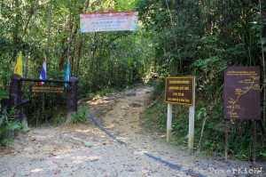 north of the famous beach town of Ao Nang and nestled into the hilly jungle roughly 5 km behind the Four Seasons Resort at Thap Khaek Beach, the trail is an inconspicuous entry into Thailand’s southern tropical jungles.
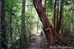
The trail totals 3.7 km, and a small map at the entrance gives hikers a brief introduction into what’s in store up ahead. The trail boasts a stream, two viewpoints, a waterfall and of course the panoramic summit. After a quick look at the map to get an idea of where we were going, it was time to climb. The beginning of the hike is flat, very scenic and nearly entirely under the canopy of the jungle; which provides good cover on hot days.
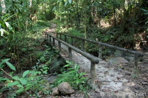
The easy pace to start off is a nice way to wake up the hiking muscles and casually stroll through the tropical greenery. For those whose curiosity is peaked by all the greenery, there are numbered signs along the way which give some details about the flora and fauna in the area. Try not to get too sidetracked as just before you know it the first landmark is in sight. A small stream splits the trail and a footbridge is there to help hikers cross the flowing water safely. A splash of the cool water on your head is definitely recommended to help keep cool.
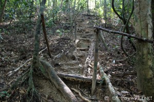
Quickly after passing the stream the the ascent upwards kicks into high gear. In sections the climb is close to vertical and the neighboring vines and tree trunks are well suited as climbing aids. Thankfully, some conscientious hikers or a noble park ranger has taken the time to build a makeshift staircase in one area; which was more than welcomed as it gave the thighs a bit of a breather.
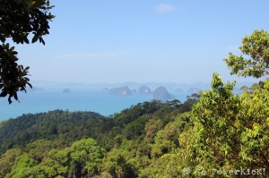
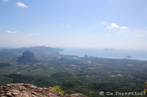
After about an hour and forty five minute climb the first viewpoint came into sight and the view was spectacular. Overlooking the portion of the Andaman Sea that lies between Krabi and Phuket, from this viewpoint Koh Hong (Hong Island), Koh Kha Ya, and if you really strain your eyes, Koh Yao (Yao Island) are all visible.
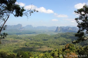
A short distance up the trail from the view of the islands is another viewing area. At this point the trail has wound more to the east, away from the water, and shows off a jungle and mountain view. Although there is only a slight peek-a-boo view of the water, the view of the valley below and the rising cliffs off in the distance is equally as stunning.
The next 1.5 km to the second view point is a continued trek through the forest. In case you forget where you are, the musical mixture of insects, grasshoppers and the occasional monkey bellowing out are great reminders that yes, you’re still in the jungle. A fork in the path soon appears and hikers are faced with a decision; veer to the right and head towards a waterfall or keep left and push on to the summit. I was anxious to see the view from the mountain peak, so we passed on the waterfall, leaned to the left and stayed the course onwards and upwards.
From the fork in the path, hiking at a modest pace, it takes about 30 more minutes to reach the summit. Just before reaching the summit the trail is lined with bright green moss and bright pink flowers, which look like orchids…but don’t quote me on this as I’m no prize-winning horticulturist. Making the final push up a limestone pathway, the sweeping view from 565 meters (1,853 feet) above sea level makes itself visible. The views from the summit are postcard-esque, and after the exhausting climb a well deserved rest should be taken to soak it all in. Perched at the top is a large limestone boulder and a few other rock outcroppings which make great seats and provide great photo opportunities.
Krabi and Ao Nang are no doubt beautiful and full of first-class activities. However, if you’re looking to break off the tourist path, this little known trail is a hidden gem just waiting for you to come explore. Although the terrain can be steep, it’s easily accessible, a great workout and refreshingly rewarding once you reach the top.
How to get there:
Located in Baan Nhong Thale, off Highway No.4034, the road to the entrance of the hike is preceded by many right and left turns onto small streets where street signs aren’t always visible. I tried to recreate the route to the hike’s entrance on Google maps to share here, but I was unfortunately unsuccessful in finding the roads.
So, my suggestion on the best way to get there would be to do what I did and hire a private car. Hiring a private care is easy and can be done at one of the many road side tour operators in Ao Nang; each one has a list of drivers who they can call to accomodate those looking to take ‘one-off’ excursions in the area.
For the day the private car was about 800 Baht ($24.30) and the driver stayed with us all day (about 5 hours). If you’re lucky like we were, you might even get your driver to make the the climb to the top with you!
Happy Hiking!
Comments
More Good Reads!

The Best Mai Tai In The World
May 23, 2014
Helicopter Over Oahu
May 10, 2014
May 2014 PowerKicK Of The Month
May 01, 2014
Bike The Golden Gate Bridge
April 29, 2014
Hua Hin Hills Vineyard
April 19, 2014
Songkran in Nan
April 10, 2014
April 2014 PowerKicK Of The Month
April 01, 2014
Mae Hong Son Motorcycle Loop: Mae Sot to Mae Hong Son
March 28, 2014
Becoming A Buddhist Monk In Thailand
March 20, 2014


